 |
 |
 |
 |
 |
||
| CARBON-3D - Theoretical Background |
|
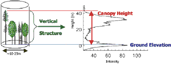
In 2003 the Friedrich-Schiller University Jena and the JenaOptronik GmbH proposed the Earth Observation mission “CARBON-3D” for global biomass mapping combination the Lidar system VCL (Vegetation Canopy Lidar) with a BRDF (Bidirectional Reflectance Distribution function) - imager on one platform. CARBON-3D improves knowledge about spatio-temporal patterns and magnitudes of major carbon fluxes between land, atmosphere and oceans, and allows quantifying above-ground stocks. Since land use, land use change and forestry activities as well as vegetation response to enhanced levels of atmospheric CO2 are major influences on greenhouse gas emissions, quantifying carbon stocks and changes is critical (Cihlar et al. 2002). Above-ground biomass stocks are also a key parameter in assessing the economic, conservation, and biofuel potential of land surfaces. The provision of a sensor that measures these stocks and their change in space and time is therefore paramount. The mission is also relevant for contributing key data on the environmental consequences of non-climatic global change resulting from continued global population growth, economic globalisation and expanding land use. The technical innovation of CARBON-3D is the simultaneous operation of a LIDAR (NASA’s Vegetation Canopy Lidar - VCL) with a multi-angle imager providing BRDF-information (Bidirectional Reflectance Distribution Function). CARBON-3D´s strength is the combined information on both, the fine-scale vertical structure of the canopy (through waveform analysis of the vertical laser profile) and biophysical properties of the surface targets (through multi-angular optical observation of vegetation targets with three-dimensional spatial structure). The spectral information allows extrapolation of the point measurements to complete spatial coverage. Large-footprint LIDAR remote sensing is a breakthrough technology for the estimation of important forest structural characteristics. The waveform information (Fig. 1) enables direct determination of vegetation height, the vertical structure of intercepted surfaces and the sub-canopy topography. A critical issue and key requirement for accurate parameter assessment is the ability to identify precisely the top of the canopy, as well as the ground reference level. Accurate retrieval of vertical forest parameters is essential as other biophysical forest characteristics, such as biomass, stem diameter and basal area, are modelled on the base of these measurements. Above-ground biomass is commonly modelled using the height information by performing regression analyses or applying allometric height-biomass relations (Drake et al. 2003). Traditional predictive models require information on stem diameter to estimate biomass and volume. This parameter is a function of tree height and thus, could be inferred on the basis of LIDAR data. One major limitation of stand-alone LIDAR systems is their capability to retrieve locally sparse information on vertical forest structure only. For spatially consistent biomass assessment, information on horizontal biophysical forest parameters e.g. phenology and forest type is essential. To gain such information simultaneously the proposed CARBON-3D mission will be equipped with the multi-angle imager in the range of VIS/NIR/SWIR.
Driven mainly by the needs of NASA’s MISR and MODIS mission, considerable work was done regarding the development of BRDF model inversion algorithms for vegetation, surface and climate parameter retrieval (Knyazikhin et al. 1998; Lucht et al. 2000). With the high spatial resolution of CARBON-3D it will be possible to exploit more complex BRDF models, i.e. physically-based approaches, for precise parameter retrieval. In addition, the use of Look-Up Table (LUT) techniques is expected to enable the derivation of the geophysical data products with a high accuracy (Barnsley et al. 2000). Data provided by the BRDF-instrument onboard the CARBON-3D satellite are also required to extrapolate spatially, regionalizing the LIDAR point measurement on vegetation structure between the transects, and to regions where no LIDAR data exist. Developing ways of using optical data (i.e. the multi-angle imager data) for spatial extrapolation of forest structure as derived from locally sparse LIDAR data is central to the mission objectives. |
[Home] [Theoretical Background] [Biomass Determination] [Mission Description] [Strategic Positioning] [The Carbon-3D Team] [References] Copyright © by FSU Jena 2004, Design by R. Fahlberg
|
||